Dorset Path Forum
This new structure was agreed at the 2023 Dorset Area AGM.
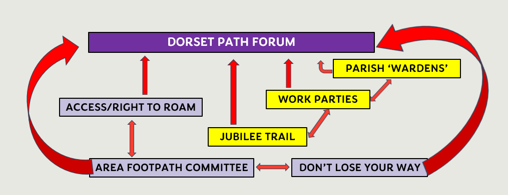
We know that there are many Ramblers members in Dorset who do not walk with groups, but, given the opportunity, would like to become involved in the core aims of the Ramblers. The new forum would be for those with mutual interests which would function outside of groups' confines, towards a common goal/objective.
The forum would be for you if you want to contribute to some part of the care of paths in Dorset, in one or more of the ways shown in the above diagram. For further information and how you can join in, please see PathForum.
RIGHTS OF WAY
What is a Right of Way
Footpaths are open only to walkers - this includes a person who uses manual or powered mobility aids such as a wheelchair or scooter. (Yellow arrows).
Bridleways are open to walkers, horse-riders (including those leading horses) and pedal cyclists. (Blue arrows).
Restricted Byways are open to walkers, horse-riders, and drivers/riders of non-motorised vehicles (such as horse-drawn carriages and pedal cycles). The category of Restricted byway was created by the Countryside and Rights of Way Act (CROW) 2000 (Plum arrows).
Byways open to all traffic (BOAT) are highways over which the public have a right of way for vehicular and other kinds of traffic, but which are used mainly for the purpose for which footpaths and bridleways are also used. (Red arrows)
You may also come across RUPPs (Road used as a public path). This classification is no longer used. Since 2006 (under the CROW Act 2000) they have generally been reclassified as Restricted Byways. (Interestingly Dorset did not have any RUPPs).
Footways (also known as a pavements or a footpaths) are the correct definition for a way or path for pedestrians, either level with, or raised and kerbed, alongside a highway.
Access Land
Open access gives everybody the right to visit mapped access land on foot. You don't have to stick to paths and you can enjoy walking, running, watching wildlife, picnicking, flying kites - or simply sit and enjoy the view.
Mountains, moors, heaths, downs and registered commons were mapped as access land, and landowners can dedicate land too.
Access Land is shown on the latest 1:25,000 Ordnance survey Maps and is also shown on Dorset Explorer
Further information can be found at Outdoor Access and Recreation
Rights of Way Problem Reporting in Dorset
If you find damage or a problem whilst walking on a right of way or any other path which is the responsibility of the local authority, please always report it. The rights of way network in Dorset is huge, 4700 footpaths, 1700 bridleways and 37 byways, nearly 3000 miles in length, so it is very unlikely that the rangers responsible for the path will find it quickly. So please report it and let them know.
There is a very good on-line reporting system Report a Problem
Fly tipping in Dorset (affecting Rights of Way or otherwise) can be reported via Report fly tipping.
Rights of Way Problem Reporting in Bournemouth, Christchurch or Poole
To report a problem in Bournemouth, Christchurch or Poole use the following link: BCP problem reporting.
Checking Reported Problems in Dorset
There is a very useful feature in Dorset Explorer where you can look at existing problem reports by zooming in to the required area from this link Dorset Explorer
Rights of Way Problem Reporting in Adjacent Counties
Hampshire Wiltshire Somerset


